
Sources & scope note: This guide is based on established travel reporting and reference material about Barrancas del Cobre, including Mexperience’s overview of Copper Canyon and the El Chepe railway.
Author context: The perspective here is shaped by work in digital transformation and travel logistics in Mexico—prioritizing clear planning, reliable ground transport, and practical risk-reduction for travelers—rather than positioning this as a substitute for on-the-ground local guiding in the canyon region.
Discover the breathtaking beauty of Copper Canyon
- Copper Canyon (Barrancas del Cobre) is a vast system of canyons
- The signature way in is the El Chepe railway, an engineering feat opened in 1961 after decades of construction.
- For the most dramatic daylight views, many travelers prefer riding eastbound from Los Mochis toward Chihuahua.
- Divisadero is the pivotal midpoint: where first-class trains meet and where many hotels, lodges, and tours are based.
- Seasons matter: May–June are typically driest; July–November brings rains and the canyon’s deepest greens; winter can be cold and even snowy in places.
Introduction to Copper Canyon
In northwestern Mexico, in the state of Chihuahua, a landscape of deep gorges and rugged wilderness has become one of the country’s most memorable travel experiences: Barrancas del Cobre, better known in English as Copper Canyon. It’s frequently compared to the Grand Canyon in Arizona, but the comparison is mostly a starting point. Copper Canyon is not a single chasm; it’s a sprawling canyon system with its own distinct topography, flora, and fauna—different in character from its U.S. counterpart and, by common descriptions, far larger.
Part of Copper Canyon’s allure is how it asks to be experienced. You can glimpse it “in passing” by taking the train straight through from one end of the route to the other. But the region rewards travelers who slow down—who step off the rails, stay in the canyon, and use a lodge or hotel base to explore viewpoints, trails, and cultural encounters. For the adventurous, the canyon can also be approached on foot, with hiking and camping as a more immersive way to understand the scale of the terrain.
What makes Copper Canyon especially compelling is the way nature and human ingenuity intersect here. The canyons were carved over time by rivers; the modern journey into them is defined by a railway line that climbs from near sea level to high mountain elevations and then descends again—threading bridges and tunnels through the Sierra Madre Occidental. In other words, the destination is extraordinary, and so is the way you get there.
Geography and Formation of Copper Canyon
Copper Canyon is best understood as a network rather than a single landmark. It’s described as a series of canyons—often cited as twenty canyons in total—formed over time by multiple rivers. Another common framing is that the system includes six major canyons carved by six rivers that ultimately merge into the Río Fuerte and flow toward the Gulf of California. Either way, the essential point holds: water shaped this region, cutting deep into the Sierra Madre Occidental and creating a complex of gorges, cliffs, and valleys that feel almost endless when viewed from the rim.
Scale is part of Copper Canyon’s identity. The region is widely described as about seven times the size of the Grand Canyon, and it spans a vast area—often cited as more than 60,000 square kilometers. That size translates into variety. Elevation changes dramatically across the canyon system, producing multiple ecozones and microclimates. Travelers can move between arid lowlands and cooler, forested highlands, sometimes within the same journey. The landscape is associated with pine and oak forests, dramatic rock faces, waterfalls, and a diversity of flora and fauna that shifts with altitude and season.
This geographic complexity is also why Copper Canyon can feel like several trips in one. A viewpoint might open onto a vast, sunlit gorge; a short distance away, the air can turn cooler in higher terrain. The canyons’ seasonal color changes—especially during the rainy months—are tied directly to this interplay of elevation, moisture, and vegetation. It’s a region where the map doesn’t fully prepare you for the lived experience of distance and depth.
The Engineering Marvel of the Copper Canyon Railway
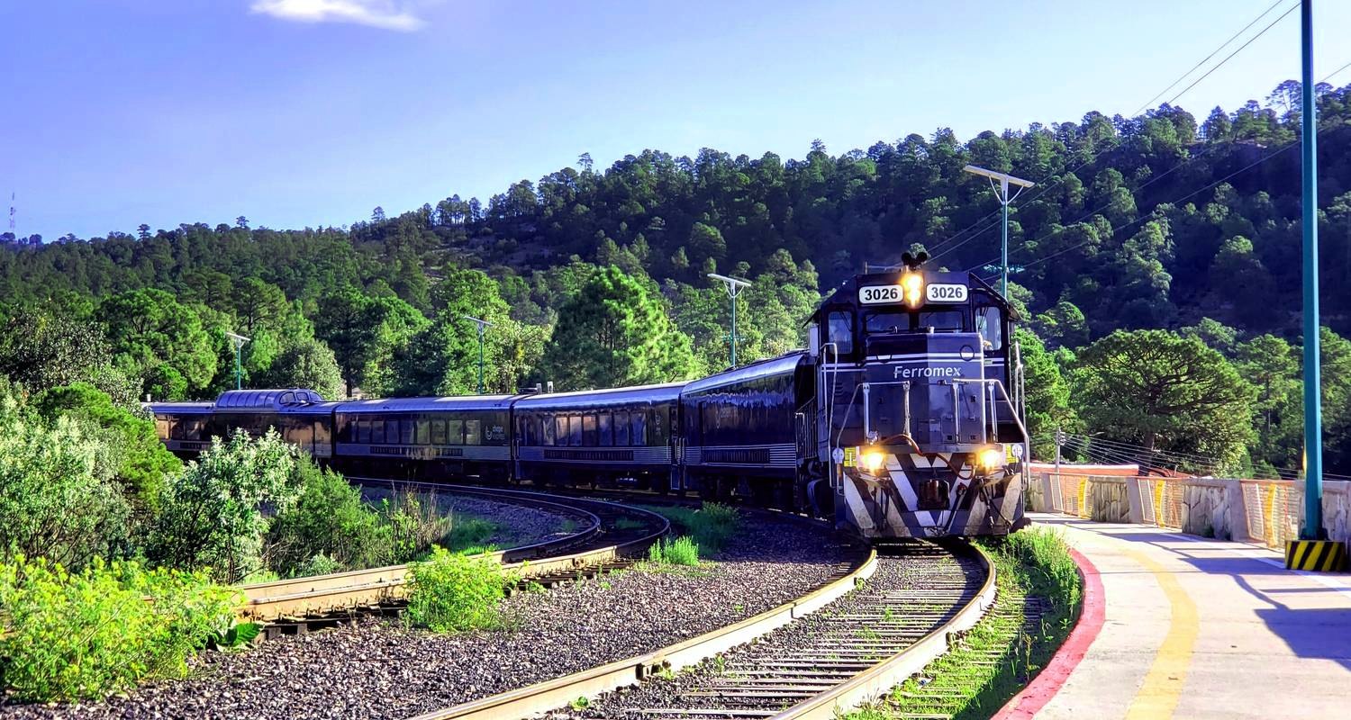
If Copper Canyon is Mexico’s great natural spectacle, the railway that crosses it is one of the country’s great human achievements. The line—widely known as El Chepe (Ferrocarril Barrancas del Cobre)—was conceived to connect the Pacific port at Los Mochis with the inland colonial city of Chihuahua. It remains the most popular—and often considered the best—way to travel into the canyon region.
One of the railway’s defining features is its dramatic change in altitude. The route begins near sea level on the Pacific coast, climbs to over 8,000 feet, and then descends again to around 2,500 feet. That vertical choreography is not just a scenic flourish; it’s an engineering problem that demanded creative solutions. Railway inclines are limited—commonly described as not exceeding fifteen degrees—so the builders had to find ways to gain and lose elevation without exceeding the constraints of rail travel.
The result is a route stitched together with bridges, tunnels, and switch-back stages. By the time the railway was completed, engineers had laid more than 390 miles of track. The line crosses dozens of bridges and passes through a remarkable number of tunnels—often cited as thirty-nine bridges and eighty-six tunnels. Superlatives are part of the story: the longest bridge runs for about a quarter mile, and the longest tunnel stretches for nearly a mile.
For travelers, these numbers translate into a particular rhythm: light and shadow as the train enters and exits tunnels; sudden openings where the landscape drops away; long, deliberate curves that reveal the canyon in stages. The railway is not merely transportation—it’s a moving vantage point, designed by necessity but experienced as spectacle.
Train Journey Experience
The train ride through Copper Canyon is often described as an attraction in its own right, and it’s easy to understand why. The route links two very different gateways—Los Mochis on the Pacific side and Chihuahua City inland—while cutting through mountainous terrain that would be difficult to appreciate by road alone. For many visitors, the journey becomes the spine of the trip: a way to access canyon viewpoints, lodge bases, and tours, while also delivering hours of uninterrupted scenery.
Two first-class trains operate across the canyon, one beginning in Chihuahua City and the other in Los Mochis. This shapes how people plan their stays, because Divisadero is where many of the region’s hotels, lodges, and tours are concentrated—especially those designed to take visitors deeper into the canyon system.
Direction matters for sightseeing. The most scenic and dramatic areas are commonly associated with the west side of the canyon. To maximize daylight on that stretch, it’s generally accepted that traveling eastbound—from Los Mochis toward Chihuahua—offers a better sightseeing experience than the reverse. In practical terms, that preference is about timing: you want the canyon’s most dramatic views to arrive when the light is strongest.
The train also supports a style of travel that’s part journey, part exploration. Rather than treating the route as a single ride, many travelers use key stops to break up the trip—stepping off to stay overnight, join guided excursions, or simply absorb the canyon from a fixed viewpoint before continuing onward.
First-Class Train Options
Copper Canyon’s rail experience is anchored by two first-class trains: one departing from Chihuahua City and the other from Los Mochis. This dual-origin setup gives travelers flexibility in how they approach the canyon—either starting from the inland highlands or from the Pacific side. In both cases, the first-class service is positioned as the flagship way to make the crossing, especially for visitors who want comfort while still being immersed in the landscape.
The first-class trains are also central to the “meet in the middle” dynamic of the route. Because the two trains converge roughly halfway near Divisadero, travelers can plan itineraries around that midpoint—using it as a natural pause for lodging and tours. This matters because Copper Canyon is not a place most people want to rush through. The train can carry you across the region in a continuous journey, but the most rewarding trips often involve stepping off the train and staying in the canyon itself.
That doesn’t make the opposite direction “wrong,” but it does shape expectations—particularly for photographers and travelers who want the canyon’s biggest moments to arrive when the light is working in their favor.
In practice, first-class rail here is less about luxury for its own sake and more about making a long, visually intense journey comfortable enough that you can stay alert to the scenery—bridges, tunnels, switch-backs, and the sudden, vertiginous openings that define the route.
Meeting Point at Divisadero Station
Divisadero station is the gravitational center of many Copper Canyon itineraries. It’s where the two first-class trains—one from Chihuahua City and one from Los Mochis—meet roughly halfway across the route. That meeting point has turned Divisadero into more than a stop; it’s a base.
A significant share of the region’s hotels, lodges, and tours cluster around Divisadero, precisely because it’s so well positioned for accessing canyon viewpoints and excursions. For travelers, this concentration simplifies logistics. Instead of trying to coordinate transport deep into rugged terrain independently, many visitors use Divisadero as a staging area: arrive by train, settle into a lodge, and then join organized tours that go farther into the canyon system.
Divisadero’s role also reflects a broader truth about Copper Canyon: the train is the iconic entry, but the canyon experience deepens when you get off the train. Staying in the region—rather than treating the canyon as scenery viewed only through a window—opens up options for outdoor activities and cultural encounters. For some, that means guided hikes; for others, it’s simply spending time at viewpoints, letting the scale of the landscape sink in without the motion of the rails.
Because Divisadero sits within the broader rhythm of the railway, it also functions as a natural breakpoint for travelers who want to pace the journey. You can ride in, pause for a night or two, and then continue—turning a single crossing into a multi-day exploration shaped around the canyon’s most accessible hub.
Best Time to Visit Copper Canyon
Copper Canyon is a year-round destination in the sense that the landscape is always dramatic—but the experience changes significantly with the seasons. Weather, trail conditions, and even the canyon’s color palette shift across the year, and those changes can influence everything from what you pack to how ambitious your plans should be.
May and June are commonly described as the driest months in the canyons. For travelers prioritizing clear skies and lower rainfall—especially those planning hikes or outdoor excursions—this drier window can be appealing. Drier conditions can also mean more predictable travel on rugged terrain, where rain can make paths slick and rivers more challenging.
From July to November, rains are most abundant. This is when the canyon’s flora is often at its most vivid, showing off deeper colors that reflect the wetter season. For travelers who want to see the landscape at its greenest and most saturated, these months can be rewarding—though rain can also complicate hiking and make weather more variable, particularly at higher elevations.
Between December and May, the canyon’s colors transition between wet and dry seasons. This shoulder period can offer a mix: less rain than the peak wet months, but still some of the lingering richness in vegetation depending on timing and location.
Winter—December through February—is the coldest period, and snow can fall in some areas of the canyon. That doesn’t necessarily rule out travel, but it changes the equation. Higher elevations can be notably colder, and travelers should be prepared for rapid weather shifts. Layering becomes essential, and plans should account for the possibility that conditions in the highlands may differ sharply from those in lower canyon areas.
In short, the “best” time depends on what you want: dry, stable conditions; lush, rain-fed color; or the quieter drama of winter landscapes. Copper Canyon’s scale means microclimates are part of the deal—so even in a chosen season, it pays to be ready for variety.
El Fuerte: The Gateway to Copper Canyon
Although the railway route begins in Los Mochis, many visitors choose to board at El Fuerte, the first main stop and one of the most popular entry points for Copper Canyon travel. El Fuerte is described as a beautiful colonial town, and its appeal is practical as well as aesthetic: it sits about an hour’s drive from Los Mochis, the city where many travelers fly in before beginning the rail journey.
This geography shapes the typical arrival pattern. Travelers often land in Los Mochis, then transfer by road to El Fuerte to start the train experience from a more atmospheric setting. For those booking through a tour service, the logistics can be streamlined: it’s common for a driver and vehicle to meet visitors at the airport and handle the transfer, reducing friction at the start of a trip that can otherwise feel complex.
El Fuerte’s role as a gateway also reflects how Copper Canyon travel is often built around a sequence of transitions: from coastal lowlands to mountain elevations, from city infrastructure to remote wilderness. Starting in a colonial town can make that transition feel more deliberate—less like a rush to catch a train and more like the opening chapter of a longer journey.
For travelers who want to “do the canyon” efficiently, it’s possible to remain on the train and simply pass through the region en route to Chihuahua City. But El Fuerte is often where the trip begins to slow down—where travelers commit to the idea that Copper Canyon is not just a train ride, but a region to explore through stops, stays, and side trips. In that sense, El Fuerte is both a literal gateway and a psychological one: the point where the itinerary shifts from transit to experience.
Activities and Adventures in Copper Canyon
Copper Canyon is often introduced through its scale and scenery, but it’s the range of activities—outdoor, cultural, and rail-based—that turns a visit into something personal. The region supports everything from soft adventure to demanding treks, and it offers multiple ways to engage with the landscape beyond the train window.
For many travelers, the first activity is simply the train journey itself. El Chepe is not just transportation; it’s a moving viewpoint across bridges, through tunnels, and along switch-backs that reveal the canyon in layers. But the deeper experience begins when you step off the train and use the region’s hubs—especially around Divisadero and other key stops—to access tours and excursions.
Outdoor options are broad. Hiking and trekking are frequently highlighted, including the possibility of more adventurous approaches like hiking and camping in the canyon. For travelers who prefer structured thrills, the Copper Canyon Adventure Park at Divisadero is known for activities such as zip-lines, suspension bridges, a cable car (teleférico), rock climbing, and rappelling. Elsewhere in the region, activities commonly associated with Copper Canyon travel include mountain biking, horseback riding (notably around Creel and its surroundings), birdwatching, and river excursions.
Natural landmarks also shape activity choices. Basaseachic Falls is widely cited as one of Mexico’s highest waterfalls and is often approached from the Creel area. Water features and rivers are part of the canyon’s identity, and excursions on waterways—such as the Fuerte River—are among the experiences travelers seek out, depending on season and conditions.
Cultural experiences are equally central. The region is home to the Tarahumara, also known as the Rarámuri, whose presence adds depth to a trip that might otherwise be framed purely as nature tourism. Visits to communities, markets, and artisan workshops are often included in cultural tours, and many travelers choose guides with local roots to better understand the land and its traditions.
Hiking and Trekking Opportunities
Hiking in Copper Canyon ranges from accessible walks to multi-day treks, and the variety reflects the canyon system’s vastness and changing elevations. For travelers who want to experience the landscape beyond viewpoints, trekking offers a direct way to understand the region’s scale: steep drops, long ridgelines, and terrain that can shift quickly from forested highlands to more arid zones.
One practical reality is that many trails can be unmarked, and the terrain can be steep and rocky. That’s why local guidance is often recommended, especially for anyone venturing beyond well-trodden paths or attempting longer routes. A guide can help with navigation and route selection, but also with timing—choosing trails that make sense for the season and the day’s weather.
Seasonality matters. In the driest months—often described as May and June—hiking conditions can be more predictable. During the rainy period (commonly July to November), the canyon’s vegetation can be at its most vibrant, but trails may become slippery and rivers can swell, changing what’s safe or comfortable. In winter, higher elevations can be cold, and snow is possible in some areas, which can affect footing and visibility.
For the most adventurous travelers, hiking and camping in the canyon is part of the appeal. This approach demands self-sufficiency and careful planning, particularly because connectivity can be limited in many areas. Even for day hikes, good footwear and a reliable way to navigate—map, GPS, or local knowledge—can make the difference between a memorable outing and a stressful one.
Cultural Experiences with the Tarahumara
Copper Canyon is not only a natural wonder; it’s also a cultural landscape shaped by the presence of the Tarahumara (Rarámuri) people. They are widely known for endurance running and for maintaining traditions closely tied to the land. For travelers, cultural experiences in the region can provide context that scenery alone cannot: a sense of how people have lived in and moved through this rugged terrain over generations.
Cultural tours commonly include visits to Rarámuri villages, markets, and artisan workshops. Travelers may encounter handmade textiles and other crafts, and some tours offer opportunities to witness traditional dances or learn about local customs. These experiences are often most meaningful when approached with respect and patience—recognizing that communities are not attractions, but living cultures.
A recurring recommendation in the region is to support community-based tourism and to engage guides who bring authentic perspectives—sometimes including guides of Tarahumara origin. This can help ensure that tourism benefits local economies and that visitors receive interpretation rooted in lived experience rather than surface-level commentary.
Respect is practical as well as ethical. Copper Canyon’s remoteness and the limited connectivity in many areas mean that travelers often rely on local knowledge for navigation, safety, and understanding what is appropriate in specific communities. Cultural engagement here is not about checking a box; it’s about traveling in a way that acknowledges the canyon as home to people as well as wildlife, forests, and rivers.
Accommodation Options in the Region
Where you stay in Copper Canyon shapes what you can do. The region’s accommodation options range from luxury hotels with panoramic canyon views to basic guesthouses and more rugged camping setups. Many travelers choose lodging not only for comfort, but for location—especially proximity to train stops and tour departure points.
Divisadero stands out as a major lodging base. It’s near the midpoint where the two first-class trains meet, and it’s also where many hotels, lodges, and tours are concentrated. For travelers who want to wake up near canyon viewpoints and have easy access to organized excursions—such as activities at the nearby adventure park—Divisadero-area lodging can be a practical choice.
Creel is another common base, often used by travelers interested in hiking, regional waterfalls, and cultural encounters. El Fuerte, as a popular boarding point and colonial gateway town, also offers accommodations that can make the first or last night of a rail itinerary feel more relaxed.
Across the region, options are often described in broad tiers: luxury properties (notably around Divisadero and in some gateway towns), mid-range hotels with local character, and budget guesthouses—particularly useful for independent travelers. Camping is possible in various areas, though formal campsites may be limited and conditions can require self-sufficiency.
Traveler feedback frequently emphasizes the quality and cleanliness of hotels, especially those overlooking the canyon. Certain properties in El Fuerte and the Divisadero area are often singled out in reviews for ambiance and service. Still, the most important accommodation decision is strategic: staying in the canyon itself—rather than only passing through—makes it easier to join tours, catch early light at viewpoints, and build in time for hikes or cultural visits without rushing to match the train schedule.
Safety Tips for Travelers
Copper Canyon is widely described as safe for travelers along established routes—particularly the main train line and the better-known tourist towns. Still, it is a remote region with rugged terrain, limited connectivity in many areas, and weather that can change quickly. Safety here is less about alarm and more about preparation.
For exploration beyond the most accessible viewpoints, hiring a local guide is often recommended. This is especially true for hiking and trekking, where trails may be unmarked and the landscape can be steep and rocky. A guide can help with navigation, route choice, and situational awareness—practical advantages in a place where a wrong turn can become serious.
Weather deserves special attention. Conditions can shift rapidly, particularly at higher elevations. Even in warmer months, packing layers and rain gear is sensible. During the rainy season (often July to November), trails can become slippery and rivers can swell. In winter (December to February), cold temperatures and even snow in some areas can affect travel plans and comfort.
Connectivity is another key factor. Cell service is limited in many parts of the canyon, so it’s wise to inform someone of your plans and expected return time, especially if you’re heading out on a hike or traveling between smaller communities.
Health and logistics matter, too. Safe drinking water is typically provided on organized tours and in hotels, but travelers should confirm before drinking tap water. Basic medical care is available in larger towns such as Creel, but serious emergencies may require evacuation to Chihuahua or Los Mochis—another reason to avoid overextending on remote routes without support.
Finally, carry cash for remote areas. ATMs are available in major gateways like Los Mochis, Chihuahua City, and Creel, but smaller stops may not have reliable access. In a region where plans can be shaped by weather and distance, having the basics covered—water, layers, cash, and a realistic itinerary—goes a long way.
Conclusion: Embrace the Adventure of Copper Canyon
A Journey Beyond the Ordinary
Copper Canyon stands apart not only because it is vast—often described as far larger than the Grand Canyon—but because it offers a layered experience: geology carved by rivers, forests and microclimates shaped by elevation, and a living cultural landscape anchored by the Rarámuri. Add the El Chepe railway—opened in 1961 after decades of construction, climbing from near sea level to over 8,000 feet via bridges, tunnels, and switch-backs—and the journey becomes inseparable from the destination.
It’s also a place that rewards intention. You can ride the train straight through and still come away impressed. But the canyon’s real depth emerges when you stop: when you base yourself near Divisadero, or use towns like El Fuerte and Creel to slow the pace, join tours, hike, and spend time with the landscape rather than just passing it by.
Planning Your Visit: Tips for a Memorable Experience
Plan around light and season. If sightseeing from the train is a priority, many travelers favor the eastbound ride from Los Mochis toward Chihuahua to catch the west side’s most dramatic scenery in daylight.
Build in at least one overnight in the canyon region—especially around Divisadero. Consider guided support for hikes and off-the-beaten-path exploration, and pack for variability: layers, rain gear, and sturdy footwear. Expect limited cell service in many areas, carry cash beyond the main cities, and treat the region’s cultural encounters with the respect they deserve.
Copper Canyon is not a quick stop—it’s a journey. Give it time, and it tends to give something back: perspective, scale, and the rare feeling of traveling through a landscape that still feels genuinely wild.
Martin Weidemann is a digital transformation expert and entrepreneur with over 20 years of experience leading fintech and innovation projects. As a LinkedIn Top Voice in Digital Transformation and contributor to outlets like Forbes, he now brings that same expertise to travel and mobility in Mexico City through Mexico-City-Private-Driver.com. His focus: trustworthy service, local insights, and peace of mind for travelers.