Table of Contents
- 1. Paseo de la Reforma’s historical and cultural significance
- 2. Historical Origins of Paseo de la Reforma
- 3. Transformation Under President Benito Juárez
- 4. Significant Landmarks Along the Avenue
- 4.1 The Angel of Independence
- 4.2 Estela de Luz
- 5. Modern Architectural Developments
- 5.1 Torre Mayor and Other Skyscrapers
- 6. Cultural Significance and Public Life
- 6.1 Leisure Activities on Sundays
- 7. Economic Impact of Paseo de la Reforma
- 8. Urban Planning Challenges and Innovations
- 9. Paseo de la Reforma as a Cultural Corridor
- 10. Conclusion: The Future of Paseo de la Reforma
Paseo de la Reforma’s historical and cultural significance
- Built in the 1860s as an imperial route linking Chapultepec Castle to the National Palace.
- Renamed after the fall of the empire to honor the liberal reforms under Benito Juárez.
- Its monuments—from the Angel of Independence to the Estela de Luz—trace Mexico’s public memory.
- Today it is both a business spine of skyscrapers and a weekend “paseo” for cyclists and runners.
Reforma Boulevard: History and Landmarks
Reforma (short for Paseo de la Reforma) is one of Mexico City’s signature boulevards, running from the historic center toward Chapultepec Park and Castle through a major business district. The core historical arc in this guide (Maximilian → Juárez renaming → later monuments like El Ángel and Estela de Luz) follows Mexperience’s published account, with a few modern skyline details cross-checked against publicly available building/engineering references.
Historical Origins of Paseo de la Reforma
Paseo de la Reforma is one of Mexico City’s principal thoroughfares, known locally simply as “Reforma.” It runs diagonally across the heart of the capital, connecting the downtown area to Chapultepec Park—an alignment that is as symbolic as it is practical. In a single corridor, it links political power, civic life, and one of the city’s most important green spaces.
The avenue’s origins are explicitly political. It was conceived in the 1860s during the Second Mexican Empire under Emperor Maximilian I. The project was inspired by European grand boulevards—an attempt to imprint an imperial vision onto Mexico City’s urban fabric. Its initial purpose was ceremonial and strategic: a direct route from the imperial residence at Chapultepec Castle to the National Palace in the city center, where government affairs were conducted.
Originally, the avenue was named Paseo de la Emperatriz, honoring Empress Carlota. The name itself signaled the court’s priorities and self-image, and contemporary accounts emphasize Carlota’s influence in decision-making at Chapultepec Castle. In that early conception, the road was not merely a means of moving people; it was a statement of authority, designed to be seen and experienced as a procession.
Over time, the corridor evolved beyond its imperial function. What began as a route for a ruler became a defining axis of a metropolis—an avenue that would later absorb monuments, museums, office towers, and everyday routines. Even today, the word “paseo” remains central to how Reforma is understood: not just a road to cross, but a place to walk, gather, and mark public life.
Reforma’s Ceremonial Origins
Timeline (how the avenue starts):
– 1860s: Maximilian I commissions a ceremonial boulevard linking Chapultepec Castle to the National Palace.
– Early name: “Paseo de la Emperatriz,” honoring Empress Carlota.
– Intended use: a visible, processional route—designed to be experienced, not just traversed.
Checkpoint for readers: if you’re trying to “read” Reforma today, start by noticing how often the avenue still behaves like a stage (glorietas, monuments, long sightlines), not just a street.
Transformation Under President Benito Juárez
The fall of Maximilian and the restoration of the republic changed the avenue’s meaning as decisively as it changed its name. After the defeat of the empire, the boulevard was renamed Paseo de la Reforma—a deliberate political re-framing meant to honor the liberal reforms carried out under President Benito Juárez. The renaming was not cosmetic; it recast the corridor from an imperial showcase into a republican symbol.
In this transformation, Reforma became a kind of civic text. Its very title—“Reforma,” or “Reform”—embedded national political identity into the city’s geography. Where the earlier name celebrated monarchy and courtly power, the new name aligned the avenue with the republic’s narrative of modernization and institutional change.
As the avenue developed, its design and function broadened. Sources describe an evolution toward a more public-facing boulevard: pedestrian ridges, tree-lined walkways, and roundabouts that would later host monuments. In other words, Reforma began to operate not only as a connector between two seats of power, but as a public realm—an urban stage where the city could represent itself.
That shift also set the conditions for later eras to leave their mark. The Porfiriato would add monumental architecture; the mid-20th century would bring beautification projects; and recent decades would layer in high-rise commercial development. Yet the Juárez-era renaming remains a hinge point: it is when the avenue’s identity moved from imperial route to national symbol—an identity that still shapes how residents and visitors read the boulevard today.
Reforma’s Shifting Civic Narrative
A quick “before/after” lens for what changed under Juárez:
– Before (imperial): a controlled ceremonial route designed to project courtly authority (Chapultepec Castle → National Palace).
– After (republican): a renamed boulevard that signals liberal reform and gradually becomes more public-facing (walkways, glorietas, monuments).
– What stays constant: Reforma remains a connector between power, culture, and green space—only the story it tells shifts.
Significant Landmarks Along the Avenue
Reforma’s identity is inseparable from its landmarks. The avenue is punctuated by roundabouts (glorietas), monuments, and cultural institutions that turn a commute into a narrative—one that moves between independence memory, indigenous heritage, and modern state symbolism. Some monuments date to the early 20th century; others are contemporary and contested. Together, they show how Mexico City uses public space to tell stories about itself.
Several of Reforma’s best-known monuments were built during the long rule of Porfirio Díaz, when monumental urban design became a tool of national image-making. Along the corridor, visitors also encounter tributes to figures such as Cuauhtémoc, the last Aztec emperor, and Christopher Columbus, reflecting how different eras elevated different versions of history in stone and bronze.
Reforma’s landmark landscape is not limited to monuments. Moving toward Chapultepec, the corridor reaches a dense cluster of cultural destinations: museums of anthropology and modern art, and the Chapultepec Zoo. The zoo carries a distinctive historical note: it was the first in the world outside China to breed giant pandas in captivity—an example of how Reforma’s adjacent institutions can carry global as well as local significance.
Below are two landmarks that capture Reforma’s dual character: one broadly beloved and celebratory, the other newer and debated.
| Landmark | Where it sits in the Reforma story | Why people stop here |
|---|---|---|
| Angel of Independence (El Ángel) | Porfiriato-era monumental nationalism; inaugurated in 1910 for the independence centennial | Iconic city symbol; common gathering point for celebrations and public moments |
| Monument to Cuauhtémoc | Tribute to indigenous heritage and national identity | A prominent, photogenic monument that signals a different historical emphasis than the independence narrative |
| Diana the Huntress fountain | Mid-20th-century beautification and civic iconography | A recognizable public artwork and meeting point |
| Chapultepec Castle | The imperial endpoint in the original boulevard logic | Historic site and museum; a hinge between city boulevard and park |
| National Museum of Anthropology (near Reforma/Chapultepec) | Cultural corridor function (museum cluster by the park) | One of the city’s major museums; anchors Reforma as a cultural destination |
| Estela de Luz | Contemporary commemoration with public controversy | A modern symbol that invites debate about design, cost, and timing |
The Angel of Independence
The Angel of Independence (El Ángel de la Independencia) is among the most recognizable landmarks in Mexico City. Built in the first decade of the 20th century and inaugurated in 1910, it was created to commemorate the 100th anniversary of Mexico’s war for independence. Its timing matters: the monument emerged during the Porfiriato, when the state invested heavily in grand symbols meant to project stability, progress, and national unity.
The Angel’s prominence is not only visual—though it dominates its roundabout—but civic. It functions as a focal point for public gatherings and national celebrations, a place where collective emotion is expressed in the open. In that sense, the monument is both a historical marker and an active piece of city life: it anchors the avenue’s identity as a space where history is not just remembered but performed.
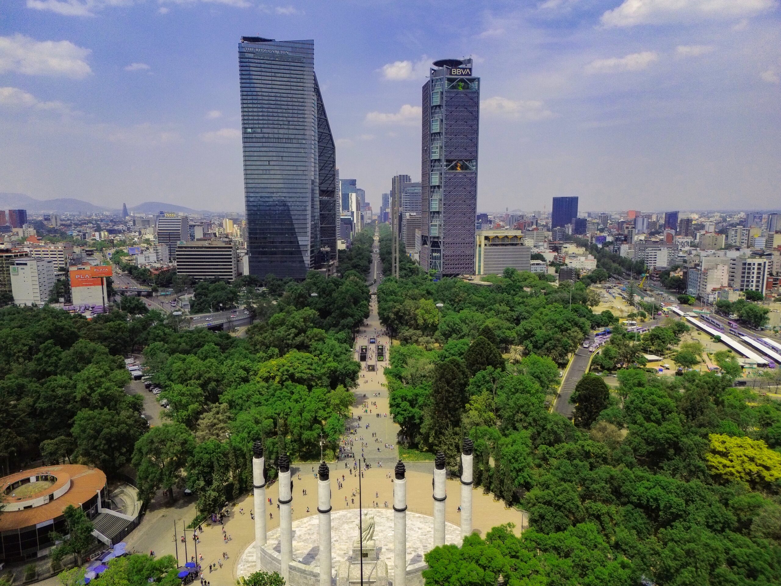
The view from the monument has also become part of its cultural footprint. Photographs taken from the top of the Angel capture Reforma as a sweeping urban axis—monuments, traffic, and towers aligned in a single frame. That perspective reinforces what the avenue represents: a corridor where Mexico City’s past and present are visible at once.
Estela de Luz
If the Angel represents established civic symbolism, the Estela de Luz (Pillar of Light) represents something more complicated: a modern monument built with the intention of commemoration, but received with controversy. The Estela de Luz was constructed to mark two milestones at once—the 200th anniversary of Independence and the 100th anniversary of the 1910–1917 Revolution.
Its location is telling. The monument sits across Reforma from the Torre Mayor, placing it in direct dialogue with the avenue’s contemporary skyline. That juxtaposition—commemorative structure facing a major office tower—captures Reforma’s constant negotiation between memory and modernity.
Yet the Estela de Luz has been criticized on multiple fronts: its design, its cost, and the fact that it was not completed in time for the 2010 bicentennial-centennial celebrations it was meant to headline. The controversy underscores a broader truth about public monuments: they are never only about architecture. They are also about trust, timing, and whether citizens feel represented by what is built in their name.
For visitors, the Estela de Luz offers a different kind of landmark experience than the Angel. It invites judgment rather than consensus—an object lesson in how contemporary Mexico City debates its symbols in real time.
Modern Architectural Developments
Reforma today is not only a historic boulevard; it is also a dense corridor of modern commercial architecture. Over recent decades, the avenue has become a premier business and financial district, lined with luxury hotels, high-rise office blocks, and a steady churn of activity that often translates into bumper-to-bumper traffic. The skyline—especially toward the west-central stretch—signals Mexico City’s role as a major economic hub.
This modern layer sits atop the avenue’s older monumental logic. Where earlier eras placed statues and columns in roundabouts, the contemporary city places towers—vertical markers of capital and corporate presence. The result is a corridor where neoclassical and modernist impulses coexist: historic monuments and cultural institutions at street level, and glass-and-steel office space rising above them.
The scale of development is substantial. Research cited on Reforma’s recent growth notes that several high-rise projects collectively provide over 200,000 square meters of Grade A office space, including buildings such as Torre BBVA Bancomer, Torre Reforma, and Torre Reforma 509 (as summarized in a Council on Tall Buildings and Urban Habitat engineering paper by Wilcock et al., 2015). This concentration reinforces Reforma’s status as a central business address—an urban brand as much as a location.
Modernization has also been shaped by disruption. The 1985 earthquake led to the collapse of several buildings along the corridor, reshaping parts of Reforma’s urban landscape and reinforcing the importance of engineering and safety in subsequent construction. In a seismic city, the skyline is never just aesthetic; it is also a technical and regulatory achievement.
Update context: Building rosters, heights, and “tallest” claims can change as new towers open; the examples below reflect widely cited figures in publicly available references at the time of writing.
| Building | Height (m) | Completed | Primary use | Why it’s notable on Reforma |
|---|---|---|---|---|
| Torre Reforma | 246 | 2016 | Office | A flagship modern tower on the corridor; often cited among the avenue’s defining high-rises (Wilcock et al., 2015) |
| Torre BBVA | 235 | 2015 | Office | Major corporate presence; part of Reforma’s Grade A office cluster (Wilcock et al., 2015) |
| Torre Mayor | 225 | 2003 | Office | A western-end anchor near Chapultepec; frequently referenced as a skyline landmark |
| Torre Reforma 509 | 138 | 2018 | Office | Illustrates continued densification and office growth along the corridor |
Torre Mayor and Other Skyscrapers
Among Reforma’s modern towers, Torre Mayor stands out as a defining reference point. Located across from Chapultepec Castle, it is described as Latin America’s tallest building and has become a visual anchor at the avenue’s western end. Its prominence is amplified by its setting: facing the park and the historic castle, it embodies Reforma’s signature contrast between heritage and high-rise modernity.
Other notable skyscrapers along the corridor include Torre Reforma (246 meters, completed 2016), Torre BBVA (235 meters, completed 2015), and Torre Reforma 509 (138 meters, completed 2018). Together with Torre Mayor (225 meters, completed 2003), these buildings illustrate how Reforma has become a laboratory for contemporary architecture and office development in Mexico City.
What makes these towers especially significant is not only their height but what they represent: the consolidation of corporate, financial, and institutional presence along a single axis. Reforma’s skyline is, in effect, a map of economic gravity. And because building here involves constraints—limited sites, historic context, and seismic risk—the towers also reflect the city’s capacity for engineering innovation under pressure.
Cultural Significance and Public Life
Despite its role as a business corridor, Reforma remains a place for paseos—strolls and shared public time. That dual identity is one of the avenue’s defining features: it can be a high-stakes artery of commerce on a weekday and a civic promenade on a weekend. The same roadway that carries office traffic also hosts runners, cyclists, families, and tourists.
Reforma’s cultural significance is reinforced by what surrounds it. Moving past Chapultepec Castle, the corridor reaches museums, including the National Museum of Anthropology, the Museum of Modern Art, and the Rufino Tamayo Museum. These institutions help define Reforma as more than a transit route; they make it a cultural destination where residents and visitors can move between public art, national history, and contemporary exhibitions.
The avenue also functions as a stage for civic expression. Sources describe it as a place that hosts political demonstrations, national celebrations, and public festivals—events that turn the boulevard into a forum. In that sense, Reforma is not just a symbol of Mexico City; it is one of the places where the city actively negotiates its identity in public.
This is why Reforma’s sidewalks and roundabouts matter as much as its lanes. The corridor’s design—broad stretches, monumental nodes, and connections to parks and museums—supports a kind of urban life that is both everyday and ceremonial. It is a microcosm of Mexico City’s density: tourists and office workers, cyclists and families, all sharing the same iconic space.
Public Life Along Reforma
What “public life on Reforma” looks like in practice (concrete examples mentioned in widely cited travel/city references):
– Weekly street reallocation: “Paseo Dominical Muévete en Bici” restricts car traffic on Sundays 8:00 a.m.–2:00 p.m., opening the corridor to cyclists, runners, skaters, and walkers.
– Cultural clustering by Chapultepec: the avenue’s west end feeds directly into major institutions like the National Museum of Anthropology, Museum of Modern Art, and Rufino Tamayo Museum.
– Civic stage behavior: the same roundabouts that hold monuments (like El Ángel) also become natural gathering nodes for celebrations and demonstrations.
Leisure Activities on Sundays
On Sundays, Reforma’s public-life identity becomes especially visible through the “Paseo Dominical Muévete en Bici” program. During this initiative, motor vehicle traffic is restricted on Sundays from 8:00 a.m. to 2:00 p.m., allowing cyclists, skaters, pedestrians, and runners to use the avenue safely. The closure transforms a major traffic corridor into a linear park—an urban gesture that changes how people relate to the city.
The appeal is partly practical: it creates space for exercise and movement in a city where roadways are usually dominated by cars. But it is also cultural. The Sunday program reinforces the idea that Reforma is not only for getting somewhere; it is itself a destination. People come to inhabit the avenue, not just pass through it.
The program also highlights a broader urban value: community engagement. By opening the street to non-motorized use, the city encourages shared routines—mini-marathon runners alongside casual cyclists, families alongside serious athletes. In doing so, Reforma becomes a weekly ritual, a recurring reminder that public space can be reallocated and reimagined.
This Sunday transformation is one of the clearest examples of Reforma’s layered identity: imperial origins, republican symbolism, modern commerce—and, still, the simple act of a paseo.
Economic Impact of Paseo de la Reforma
Reforma’s economic role is as central as its cultural one. The avenue runs through one of Mexico City’s main financial and business districts and one of its main tourist zones, making it a corridor where commerce, hospitality, and public institutions intersect. Its address value—both symbolic and practical—has helped concentrate corporate offices, banks, embassies, and luxury hotels along its length.
Research on the corridor’s broader economic context points to Mexico City’s significance as an investment magnet. One cited figure notes that the city received $13.5 billion in foreign direct investment in 2010, with 70% of the country’s total investment concentrated in the capital. Reforma, as a premier business spine, is closely associated with this concentration of capital and decision-making.
Commercial real estate development along the corridor has been robust. In recent years, sources describe over one million square meters of office space under construction in Mexico City—framed as twice the amount in Manhattan—a comparison that underscores the scale of building activity being discussed. (That “twice Manhattan” framing is a source-made comparison rather than a precise like-for-like measurement, but it conveys how intense the development cycle has been.) Reforma’s cluster of Grade A office towers is part of that momentum, reinforcing the avenue’s role as a high-demand market for premium workspace.
The economic impact is not limited to office rents and corporate presence. Reforma’s proximity to major attractions—Chapultepec Park, museums, monuments—supports tourism flows that feed hotels, restaurants, and services. The avenue’s iconic status also makes it a default route for visitors, which in turn shapes where businesses choose to locate.
At street level, the economic story is visible in the daily rhythm: bustling business activity, heavy traffic, and constant movement between offices, hotels, and cultural sites. Reforma is, in effect, a corridor where Mexico City’s global-facing economy meets its public-facing identity.
Reforma’s Value and Friction
Reforma’s economic upside comes with real friction:
– Benefits: premium office concentration (Grade A towers), strong hotel/tourism demand, and a “signal address” for institutions and brands.
– Costs: frequent congestion and slower surface mobility; construction disruption as new projects rise; and price pressure that can push up nearby commercial and residential costs.
– Practical implication: the same factors that make Reforma valuable (centrality + visibility) also make it contested space—where mobility, livability, and development are constantly negotiated.
Urban Planning Challenges and Innovations
Building and maintaining Reforma is an urban planning challenge precisely because the avenue carries so many roles at once. It must function as a major traffic artery, a ceremonial boulevard, a business district, and a cultural corridor—often simultaneously. That complexity is compounded by Mexico City’s physical realities, including seismic risk and constrained space for new development.
One of the most significant constraints is seismic activity. Sources emphasize that building on Reforma requires innovative engineering solutions to ensure safety, especially as the corridor has become a preferred site for high-rise construction. The memory of the 1985 earthquake, which caused the collapse of several buildings along the avenue, remains an important context for understanding why structural design and regulation matter so much here.
Another challenge is the limited availability of sites along a corridor that is already dense and historically layered. New towers must be integrated into an urban fabric that includes monuments, museums, and long-established public spaces. This is not simply an architectural question; it is a planning question about how to preserve the legibility of the avenue—its sightlines, its symbolic nodes, its pedestrian experience—while accommodating growth.
Reforma has also been shaped by periodic waves of renovation or beautification, often driven by national presidents or city mayors. Additions such as the Diana fountain in the mid-1900s reflect how political leadership has repeatedly used the avenue as a showcase for urban improvement. These interventions can refresh public space, but they also reveal how Reforma is frequently treated as a national stage—an avenue where visible change carries political meaning.
Finally, there is the everyday planning tension between mobility and livability. Reforma’s frequent traffic congestion sits alongside programs that temporarily prioritize cyclists and pedestrians. The Sunday closures demonstrate one approach: time-based reallocation of space. In a corridor as symbolic as Reforma, such choices are not merely technical—they signal what kind of city Mexico City wants to be.
Reforma Development Planning Constraints
Planning constraints on Reforma (and what tends to work):
– Seismic risk → prioritize modern structural engineering and strict code compliance for high-rises.
– Heritage + symbolism → protect sightlines to major monuments and avoid “blocking” key civic nodes.
– Limited buildable sites → reuse/retrofit where possible; expect complex staging and logistics.
– Mobility vs. public space → use time-based street management (e.g., Sunday closures) to test reallocation without permanently removing capacity.
– Congestion reality → design for multimodal access (walking, cycling, transit connections) so the corridor isn’t only car-dependent.
Paseo de la Reforma as a Cultural Corridor
Reforma’s cultural power comes from accumulation: monuments, museums, public events, and the simple fact that so many people pass through it. The avenue is often described as a living narrative of Mexico City’s history and transformation, where collective memory is renewed through celebrations, protests, and everyday use. It is a place where the city’s identity is not stored in a single building but distributed across space.
The corridor’s cultural institutions are central to this role. Along and near Reforma are some of Mexico City’s most important museums. Their presence turns the avenue into a spine of cultural access: visitors can move from monument to museum to park in a continuous urban sequence.
Chapultepec Park, at Reforma’s western terminus, deepens the corridor’s cultural and ecological significance. Described as the “lung” of the city, Chapultepec provides 678 hectares of recreational space and environmental value. Reforma’s connection to this park is not incidental; it is part of the avenue’s original logic as a route to Chapultepec Castle, and it remains part of its contemporary appeal as a gateway to green space.
Reforma’s cultural corridor identity is also shaped by its international reputation. It has been recognized in international surveys as one of the best streets in the world, celebrated for cultural, gastronomic, and recreational offerings. While such recognition can be subjective, it reflects a broader reality: Reforma is legible to outsiders as a signature urban experience, a place where Mexico City’s scale and complexity can be encountered in a single walk or ride.
Ultimately, Reforma’s cultural corridor is not a curated museum district separated from daily life. It is embedded in the city’s working core—where office towers rise near monuments, and where a Sunday bike ride can pass within sight of both national history and contemporary capital.
East-to-West Avenue Corridor
A “corridor map-in-words” you can follow from east to west:
– Historic center edge → civic/political gravity (downtown side)
– Monument nodes (glorietas) → national symbols like El Ángel and other commemorative points
– Business spine → clusters of offices, hotels, and towers that signal the financial district
– Chapultepec gateway → Castle + museum zone (Anthropology, Modern Art, Tamayo nearby)
– Park terminus → Chapultepec Park as the green counterweight to the avenue’s density
Conclusion: The Future of Paseo de la Reforma
Reforma’s future will likely be shaped by the same tension that has defined its past: the need to reconcile symbolism with function. The avenue began as an imperial route, was rebranded as a republican emblem, and later became a showcase for monumental nationalism and modern corporate development. Each era has used Reforma to project an idea of Mexico—sometimes unified, sometimes contested.
The corridor’s continued evolution seems inevitable because it sits at the intersection of major forces: economic growth, cultural tourism, and urban mobility. Its concentration of Grade A office space and landmark towers signals that it will remain a prime business address. At the same time, its museums, monuments, and proximity to Chapultepec ensure it will remain a central tourist and cultural route.
Urban planning decisions will be crucial. Mexico City’s seismic reality makes engineering innovation non-negotiable, especially as high-rise development continues. Meanwhile, the popularity of Sunday closures suggests a public appetite for reclaiming street space for people rather than cars—at least part of the time. The challenge is to balance a corridor that must carry traffic with one that residents also want to inhabit.
Reforma will also continue to be a site where public meaning is debated. The controversy around the Estela de Luz shows that new symbols can provoke skepticism as well as pride. That dynamic is not a flaw; it is evidence that Reforma remains a living civic space, where the city argues about what deserves commemoration and how.
If Reforma’s past is any guide, its future will not be a single plan but a series of layered decisions—each one adding another chapter to Mexico City’s most emblematic avenue.
Reforma’s Pathway Forward
A realistic “what happens next” pathway for Reforma:
– Pressures: continued office demand + tourism + congestion + seismic constraints.
– Choices: where to allow height/density, how to protect monument sightlines, and how often to reallocate lanes for people (like Sunday programs).
– Checkpoints: safety performance in new builds, pedestrian comfort at key nodes, and whether mobility improvements reduce the feeling of constant gridlock.
– Outcomes: Reforma either becomes easier to inhabit (not just traverse) or remains primarily a high-value but high-friction corridor.
Exploring the Multifaceted Paseo de la Reforma
A Historical Journey Through Time
From Maximilian’s imperial boulevard—Paseo de la Emperatriz—to Juárez’s republican Reforma, the avenue has repeatedly been repurposed to reflect political change. Its monuments, especially those built during the Porfiriato, continue to anchor national memory in public space.
The Avenue as a Cultural Hub
Reforma’s cultural density—museums, monuments, Chapultepec Park—makes it a corridor of shared experience. It is a place where tourists and residents encounter Mexico City’s history and contemporary life in the same walk.
Economic Significance and Urban Development
As a central business district, Reforma concentrates corporate offices, hotels, and investment-driven development. Its modern towers and expanding office footprint underline the avenue’s role as an economic engine as well as a symbol.
Modern Challenges and Future Prospects
Seismic risk, limited space, traffic congestion, and public demands for livable streets will shape Reforma’s next phase. Programs like Muévete en Bici hint at a future where the avenue’s value is measured not only by throughput, but by how well it serves public life.
This guide is edited with a traveler-first lens shaped by Martin Weidemann’s background in digital transformation and his current focus on trustworthy travel and mobility insights for Mexico City.
Details such as building superlatives, development totals, and program operations may change as new projects open and city policies evolve. The historical narrative reflects widely repeated accounts, and current figures draw on publicly available information at the time of writing. For the latest on Sunday street closures and major construction impacts, check current city updates before visiting.
Martin Weidemann is a digital transformation expert and entrepreneur with over 20 years of experience leading fintech and innovation projects. As a LinkedIn Top Voice in Digital Transformation and contributor to outlets like Forbes, he now brings that same expertise to travel and mobility in Mexico City through Mexico-City-Private-Driver.com. His focus: trustworthy service, local insights, and peace of mind for travelers.